I reached a dead end in my research about road numbers (but this didn't stop me from making a cool map and finding some interesting insights)
February 7, 2022
On May 7, 2022 a Hungarian version of this article has been published on Qubit.hu, a Hungarian popular science website.
I have been wondering for some time about the system behind the numbering of roads in Hungary. The system itself is simple: the main road that leads from Budapest to Vienna is number 1, the other main roads radiating out from the capital are numbered in clockwise sequential order. Connecting roads have two (or sometimes three) digits. But why is this the system? How long has it been like this? What happened when the borders of the country changed?
Of course, my pondering didn’t start from just thinking about the way roads are numbered. I wanted to make a map where roads are colored according to their numbers and then write an article about it – fleshing out all the historical details of the topic. Well, the latter part did not fully work out, as you will soon learn. Nevertheless, you can find the map below.
My quest for an original source
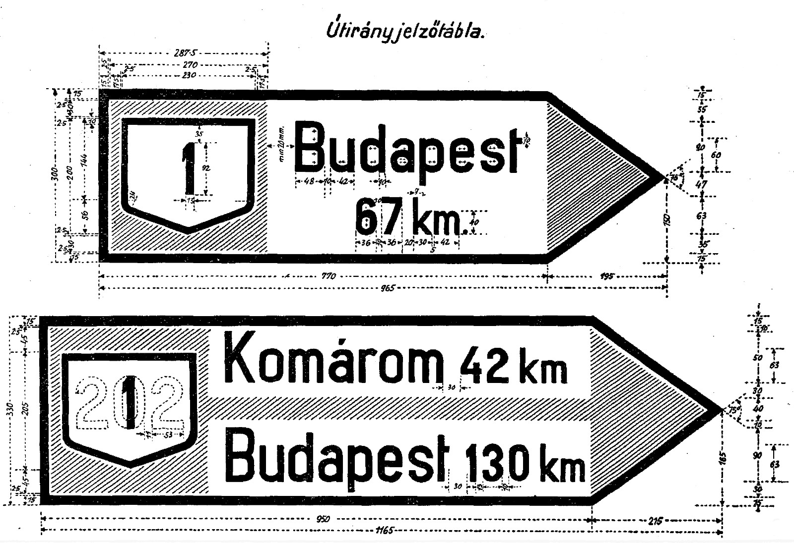
After a few searches on the internet, I established that the numbering system was designed by István Benke. Source here, archived version here. I also had multiple sources that confirm that the system was published in Decree no. 70.846/1934 of the Ministry of Commerce and Transportation of the Kingdom of Hungary. The first such source is in the Official Journal of Pest-Pilis-Solt-Kiskun County in 1935. Pest-Pilis-Solt-Kiskun vármegye hivatalos lapja, January 10, 1935 (XXXIII/2), p. 16. Note: many of the sources mentioned in the article, including this one, are behind a paywall. These were digitized by Arcanum, a small company in Hungary specializing in the archival of historical documents, such as newspapers, gazettes, and other periodicals. Another contemporary source that mentions it is Decree no. 117.100/1938, which describes road signage standards and declares that road numbers should be used according to Decree no. 70.846/1934. I also found a map from 1940 where the road numbers of territories that Hungary captured during World War II are integrated into the existing system.
What I did not find was the actual decree. It was not published in the Decrees of Hungary, 1934 publication and although some websites and modern articles refer to it, its contents are nowhere to be found online.
Instead of actually going to libraries and searching through archives, I decided to send emails.
- First, I emailed the Road Infrastructure Operations Department of the Ministry for Innovation and Technology, my best guess for being the relevant authority, asking whether they have the text of the decree in their archives. They promptly replied that they do not have this document and I should contact the Kiskőrös Museum of Road History.
- Then, I sent an email to the museum; one of their researchers replied that he himself had tried to find this document without luck and it may be available in the National Archives.
- Finally, I sent an email to the National Archives of Hungary. After sending some emails back and forth trying to find the right person, I got the following reply:
The Ministry of Commerce operated from 1889 to 1935, but only its records from 1889 to 1899 were transferred to the National Archives. The documents of the presidential department (where decrees were kept) were not handed over by the Ministry. Thus, the presidential documents, together with the records of the subdepartments from 1900 to 1935, were completely destroyed in the building of the successor ministry (Ministry of Trade and Transport) during the 1944/45 military operations. The Siege of Budapest towards the end of World War II took place between December 24, 1944 and February 13, 1945.
I was flabbergasted. Is it… gone? For real? Is there literally no way of recovering the original text of the Decree? There may be, as there could be copies in some archives, but finding it is probably harder than looking for the proverbial needle in the haystack.
Map of road numbers
Eventually, I got over this loss (it did cause me to think about life, its randomness and finiteness), and decided to make the map I had in mind in the first place.
I’ll leave the technical details to the Python notebook which generates the map, and focus on the map itself.

Looking at the map, we can make some interesting observations:
- We can clearly see the radial pattern of road numbers. 1-digit roads are the main roads, and the roads to the right of them (when looking at the road from Budapest towards the border) have the same first digit as they do.
- Motorways also follow this pattern, but sometimes deviate into “foreign” territories – such as the M6/M60 between Szekszárd and Pécs, M3 to the east of Nyíregyháza, or the M35 to the south of Debrecen.
- There are some roads that don’t follow the radial pattern: M0, a ring road around Budapest, and M9, which is planned to be a west-east motorway, but now is only a bridge across the Danube near Szekszárd. M8 is a planned motorway with ony one segment built so far: a bridge on the Danube to the south of Budapest.
Some outliers
We can see some outliers among the non-motorway roads as well, most notably Road 13, 84, and 86. Road 3407 also protrudes into the area of 4X roads, but it is a minor road and I could not find much information on it, therefore I will not discuss it further.

An interesting first step in our investigation can be leafing through Road Atlas of Hungary, published by Kartográfiai Vállalat in 1963. The legend of the map states that a full line indicates a “dust-free” (i.e. paved) road, while hollow lines (whose middle is white) indicate unpaved roads.

All three of these roads were mostly unpaved in 1963, so they had to be built essentially from scratch. This might contribute to them getting a new number.
Road 13
Road 13 runs from Komárom to Kisbér in a North–South direction (about halfway between Győr and Tatabánya). In the beginning of the 60s, its number was 808, in accordance with the numbering scheme discussed above. In 1962, Fejér Megyei Hírlap, January 14, 1962 it was announced that Road 808 would be modernised, thereby “significantly improving road traffic in the area”. This took a while: this renovation was only finished in 1966. Magyar Nemzet, January 1, 1966 At this time, the road is still referred to as 808. The first clear mention of it as Road 13 is from 1979. Autó-Motor, December 21, 1979
Since I found an article from 1969 that refers to nearby roads differently than what their number was in the 1963 atlas, Magyar Hírlap, January 24, 1969 refers to the road between Mosonmagyaróvár and Rajka as Road 15, whereas in the atlas it is 1a. I had the hunch that there may have been a larger restructuring of the road numbering system in the years inbetween. The first actual source I found was a paper by László Tóth on the history of the Hungarian road network, where he says that main roads were given new numbers in 1965. Tóth László: Az országos úthálózat fejlődése. In A Kiskőrösi Közúti Szakgyűjtemény Évkönyve 1987-1993. (1995) p. 13. While I was unable to find the actual decree as it was probably published in Közlekedési Közlöny (“Transportation Gazette”), which is not available online, I did find an article about this change in Autó-Motor, Autó-Motor, December 6, 1965 where the author mentions this change and that it is in effect starting January 1966. There is also a map attached, which shows that the very short road between Komárom and the Danube (with the bridge to Komárno, Slovakia) now has the number 13, but Road 808 is still not considered a main road and does not have a new number.
One speculative reason why road 808 might have been renamed to 13 in the end is the following. Its quality was greatly improved between 1962 and 1966, so it deserved a two-digit number, but all the 8X numbers were already taken. Therefore it got this not-entirely-up-to-code number.
Road 84

Opening ceremony of Road 84 near Sümeg. Source: Volán III/1, January 1969. Road 84 is a main road that connects Lake Balaton with Sopron, a town in the west of Hungary (and then continues to Vienna as Ödenburger Straße B16 on the Austrian side of the border), and should be a 7X road between Jánosháza and Lake Balaton. My hypothesis is that it has a single symbol to make navigation easier: after all, Balaton is a popular tourist destination – and it already was one in the 60s, when the road was built.
In 1963, it was already called Road 84 between Sopron and Jánosháza; Road 751 connected Jánosháza and Sümeg; the minor roads between Sümeg and Lake Balaton had no numbers. In May 1966, the road as a whole was renamed to 84. Autó-Motor, December 6, 1965 At that time, there were heavy works on the road improving its quality. The new road was officially opened on December 10, 1968. Napló, December 13, 1968 The article about its opening says: “Road 84 is indeed a modern project; it has great touristic importance. This is why it was built: it is a part of the regional development plan. […] The road brings Western Europe closer as well: the journey of people travelling from Austria, West Germany, or Italy will be significantly shorter both in kilometers and duration.”
Road 86
Road 86 follows the Roman trade route called Amber Road — it has been an important North-South route from the Baltics to the Adriatic Sea for centuries. Of course, it was also undeveloped for a long period before it became a main road. The route of today’s Road 86 was covered by Road 821, 827, 842, and 735. In 1966, Road 821, 827, 842 were collectively renamed to Road 86, but the segment between Körmend and Rédics (the southernmost part) did not get a new name yet. Autó-Motor, December 6, 1965 When reading this, you may be wondering “What if another road already had this number?”. This is an excellent question! Road 86 was the road between Pápa and Karakó in the 1963 atlas – it is in a completely different part of Western Hungary than the modern Road 86. Today that road is a 4-digit minor road, Road 8403.

The first mention of the upgrades that I can find is from 1967: a short article was published in Kisalföld. Kisalföld, January 20, 1967 It said: The inclusion of the south-western border region in international tourism was discussed on Thursday in Zalaegerszeg. It was agreed that the landscapes of Zala and Vas counties rich in natural beauty, the Göcsej and Őrség regions, would be opened to international tourist traffic. The former Roman road passing through the two counties will be used for tourism. The Hungarian section of this road leads from Rédics in Zala County through Zalalövő and Körmend to Szombathely. The restored road will be opened on 1 May in the presence of representatives of ten European countries with the slogan issued by the United Nations: “Tourism is the road to peace”. In reference to this, the renovated route is called the “Way of Friendship”.
In March, Yugoslavia joined the initiative, designating a route between the Hungarian border and the Adriatic Sea through today’s Slovenia. Zalai Hírlap, March 9, 1967 On May 1, the road was officially opened. Zalai Hírlap, May 3, 1967 The first source where the southern part of the route is actually called Road 86 shows up in August 1968. Vas Népe, August 25, 1968.
While reading these articles, I had to wonder: how on Earth did they build a 100 kilometer long road in basically no time? There were only about seven weeks between the announcement and the opening ceremony! Well, it turns out that they probably did not actually build the road, they merely renamed existing ones. Nine years later, in 1977, an article Zalai Hírlap, October 2, 1977 said that traffic is increasing on Road 86, so it has to be improved, especially since it will become a part of the international road network with the symbol E65. According to the article, there are too many turns and hills and the road itself is not wide enough. The improvement plan included fixing these issues as well as creating rest stops and gas stations along the road. It is also mentioned that international routes should not have level crossings with railways, so this should be fixed near Zalalövő. Can you guess when the level crossing was finally replaced by an overpass here? In 2016.
Closing thoughts
Before writing this article, I did not think very deeply about the history of road numbers. I knew that they were assigned at one point, but I did not consider the fact that there was a time when brand new roads were being built, so numbering could change drastically. I also did not think about the time when roads became paved – although I have travelled on unpaved roads, I somehow subconsciously thought that main roads had “always” been paved. Well, it turns out, this was not the case for Hungary until the late 60s.
❧
While I managed to gather a lot of sources for this research, I also reached out to the Kiskőrös Museum of Road History for sources on the three outlier roads. I have not received a reply by the time I published this article. If I do, I will update it accordingly.