Hungarian municiaplity name prefixes
August 6, 2015
Hungarian municipalities have unique names that consist of one (potentially compound) word. This was not the case until the end of the 19th century: multiple villages could have the same name, sometimes even in the same county. This caused trouble not only for the postal service but also related to taxation and conscription. Hence the standardization: every name must be unique; in case of a duplcate, the municipality names got a prefix based on their general location. I investigated these prefixes: their spatial distribution and the origin of those names.
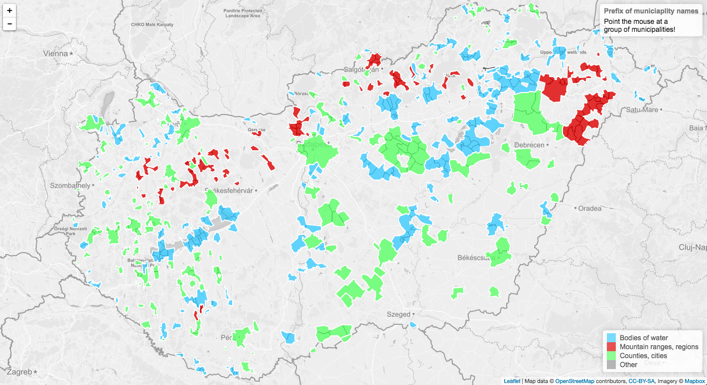
The final map can be found here.
The work of the Hungarian Settlement Register Committee
Róbert Bagdi Bagdi, Róbert: Településnevek Ung és Bereg vármegyében az I. világháborút megelőző két évtizedben. Közép-európai közlemények, (9) 3. pp. 137-149. (2016) lists a number of extreme cases: in 1863, there were 18 Kisfaluds in the country, 13 Csehis, 9 villages called Almás, and 5 called Szenterzsébet.
Act IV of 1898 on the names of municipalities and other places set out to fix this issue by forming the Hungarian Settlement Register Committee to standardize municipality names.
Gábor Farkas Farkas, Gábor: A Községi Törzskönyv Bizottság tevékenysége Fejér megyében. Levéltári Szemle, (30) 3. pp. 333-340 (1980) gives examples of the Committee’s decisions in Fejér County. Some names were updated to follow modern orthography: Gánth, Vaál, and Moór to Gánt, Vál, and Mór. Hyphens were removed from names, both in the case of two villages having merged together (Gút-Tamási to Gúttamási) and the case of qualifiers (Új-Barok (New Barok) to Újbarok). The two villages called Almás were also renamed: one to Dunaalmás and the other to Rácalmás referring to the ethnic Serbs, who were called rác, who lived there.
Creating the map
In the end, thanks to the work of the Committee, municipality names were standardized across the country. I decided to focus only on geography-based prefixes. After all, these are the cases where showing these on a map gives the most insight.
The map creation process was relatively simple, though it required a lot of manual work.
- I dowloaded the list of Hungarian municipaliy names from the website of the Central Statistical Office.
- After sorting the municipality names alphabetically, I identified groups where at least three letters were the same at the beginning with a simple Excel function.
- Using my expertise in Hungarian language and geography, I assigned each group to a category: whether it was based on a county or city name, a mountain range, or a body of water. Some groups were discarded altogether (where the prefixes were non-geography related, e.g. Great, Lower, New etc.).
- I used Quantum GIS to merge the municipality boundary shapefiles from Geofabrik with my data.
- I created simplified polygons and export them in GeoJSON format.
- I put together a page using the Leaflet javascript library. The background map uses tiles from Mapbox.
- I admired the end result: a map of Hungarian municipality name prefixes.